Perranporth (Cornish:
Porthperan)[1]
is a small seaside resort town on the north coast
of Cornwall, England, United Kingdom. It is popular
with surfers and tourists because of its spectacular beach, and
Atlantic swell. It is 6 miles (10 km) southwest of Newquay[2]
and 7 miles (11 km) northwest of Truro.
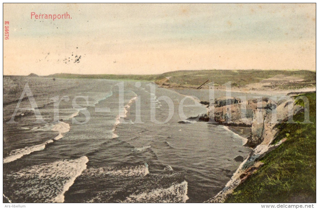
Perranporth and its 3 miles (5 km) long beach face the
Atlantic Ocean.[3]
It has a population of 3,066,[4]
and is the largest settlement in the civil parish of Perranzabuloe. It has an electoral ward in its
own name the population of which at the 2011 census was
4,270.[5]
The village's modern name comes from Porth Peran, the
Cornish for the cove of Saint Piran, the patron saint of Cornwall. He
founded St Piran's Oratory on Penhale Sands near
Perranporth in the 7th century. Buried under sand for many
centuries, it was unearthed in the 19th century.
The Voorspoed ran ashore in a northerly gale in Perran
Bay on 7 March 1901, while travelling from Cardiff to Bahia. The
wreck was one of the last to be looted.[6]
Perranporth Airfield, built during
World War II as an RAF fighter station, is now a civil airfield. It
is located at Cligga Head, on the plateau
above the cliffs.[3]
Until the 1960s, Perranporth was served by a railway line. Built
as the Truro and Newquay Railway, the line
ran from Chacewater to Newquay
and the principal intermediate stop was Perranporth
station.[7]
Perranporth also had a second station, known as Perranporth Beach
Halt.
Perranporth is centred on a main street, St Piran's Road, part
of the B3285 Newquay to St Agnes road. The village centre has
various shops and cafés including a Co-operative store, Premier
convenience store, the Camelot restaurant and seven pubs. The
long-distance South West Coast Path runs past the
village. There is a long-distance coach service provided by
National Express (service 316)
which runs between London and Perranporth.
Perranporth is a popular family holiday destination. A wide
sandy beach, Perran Beach, extends northeast of the town for
about 3 km (nearly 2 miles) to Ligger Point. The
beach faces west onto Perran Bay and the Atlantic Ocean and is a popular surfing
location.[3]
There are lifeguard beach patrols from May to September and the
beach is generally safe for bathing, although there are dangerous
rip currents around Chapel Rock at ebb tides.
At the south end of the beach are cliffs with natural arches, natural stacks and tin-mining adits. There
is a youth
hostel above the cliffs at Droskyn Point.
Nearby is the 19th century Droskyn Castle, formerly a hotel and now
divided into apartments.
Perran Beach is backed by extensive sand
dunes which extend nearly a mile inland. Known as Penhale Sands, the dunes are used for orienteering competitions and there is an army
training camp which includes a live firing range, over which
Ministry of
Defence byelaws apply[8]
and a golf course on the dunes. The dunes are not to be used by
naturists, although the far north end of the beach
is still a fairly accepted place for nudists. The dunes are also a
valuable resource for wildlife, with many rare plants and insects
including Cornwall's largest colony of the Silver-studded Blue, a Red Data Book species.[9]
Southwest of Perranporth, the coast becomes more rocky, with
cliffs rising to about 300 feet (90 metres) at Cligga Head. These
cliffs form the Cligga Head SSSI (Site of Special
Scientific Interest), noted for its geological and biological
characteristics.[10]
A
postcard or
post card is a
rectangular piece of thick paper or thin
cardboard intended for writing and mailing without
an
envelope. Shapes other than rectangular may also be
used. There are novelty exceptions, such as
wood postcards, made of thin wood, and copper
postcards sold in the
Copper Country of the U.S. state of
Michigan, and
coconut
"postcards" from tropical islands.
In some places, one can send a postcard for a lower fee than for
a letter. Stamp collectors distinguish between
postcards (which require a stamp) and postal cards (which have the postage pre-printed
on them). While a postcard is usually printed by a private company,
individual or organization, a postal card is issued by the relevant
postal authority.
The world´s oldest postcard was sent in 1840 to the writer
Theodore Hook from Fulham in London, England.
The study and collecting of postcards is termed deltiology.
La carte postale est un moyen de correspondance écrite qui se présente sous la
forme d´un morceau de papier
cartonné rectangulaire, de dimensions variables (le format
le plus courant est le format A6, soit
10,5 × 14,8 cm), envoyé
sans enveloppe, l´adresse et l´affranchissement y
étant porté directement, aux côtés du message.
Een ansichtkaart (ook ansicht of
prentbriefkaart) is een kaart met op de ene zijde
een afbeelding. In de eerste tijd, eind
negentiende eeuw, noemde men het ook wel
aanzichtkaart. Het woord is ook een verkorting van het
Duitse Ansichts(post)karte.
Veel ansichtkaarten worden verstuurd tijdens de vakantie. Men wil de thuisblijvers laten zien hoe
mooi de plek is waar men naar toe is gegaan. De kaarten worden ook
als groet of wens (bijvoorbeeld als kerstgroet of nieuwjaarswens)
gestuurd.
De ontwikkeling van de ansichtkaart begint in de loop van de
jaren tachtig van de 19e eeuw, toen de postwet in
zowel Oostenrijk als Duitsland zo werd aangepast dat het monopolie
op het uitgeven van postkaarten kwam te vervallen. In de loop van
de jaren negentig van de 19e eeuw begon de de
prentbriefkaart vooral in Duitsland aan een grote opmars, omdat ze
veel werden verzameld. Bij de oorspronkelijke ansichtkaarten was de
hele achterkant gereserveerd voor de adressering. Men noemt deze
kaarten voorlopers. Tot 1905 mocht in
Nederland de achterkant van een prentbriefkaart alleen gebruikt
worden om naam, adres en woonplaats op te schrijven. Het verzonden
bericht bestond dus uit weinig meer dan de afbeelding, want het was
niet toegestaan om iets op de voorkant te schrijven. Dit had te
maken met de lage frankeerwaarde. Het verzenden van kaarten met een
bericht was veel duurder.
Kort hierna begonnen andere landen met het introduceren van een
gedeelde achterkant. Bij deze kaarten is de achterzijde in tweeën
gedeeld: de rechterhalf is bestemd voor het adres, dat op
voorgedrukte lijntjes kan worden geschreven, en links is ruimte
voor een bericht. Zo kon de zegetocht van de ansichtkaart als
communicatiemiddel beginnen. De voorzijde werd nu exclusief bestemd
voor het beeld.